The Finchampstead Ridges
The Finchampstead Ridges
Nestled on the edge of Wokingham in Berkshire, the Finchampstead Ridges rise quietly above the surrounding landscape, offering panoramic views, stirring walks, and a rich tapestry of natural and human history. This remarkable area, preserved in part by the National Trust, stands as both a geological wonder and a beloved destination for those seeking connection with the countryside. From the ancient sands beneath your feet to age-old wells and meandering rivers, the Ridges contain much more than you might at first think.
Geology of the Ridges
The story of the Finchampstead Ridges begins millions of years ago, when the land that is now Berkshire lay beneath prehistoric seas and rivers. The Ridges themselves are a product of complex geological forces that shaped southern England over ages. The foundation of the Ridges is predominantly composed of Bagshot Sand, a sedimentary deposit formed during the Eocene epoch some 56 to 34 million years ago.
This Bagshot Sand, a tangible remnant of ancient deltas and shallow seas, can be seen along the exposed banks and in the scattered sandy soils of the area. Over time, the sand beds hardened, and the landscape was further moulded by the slow but unstoppable forces of erosion and uplift. The Ridges, standing above the flat Thames Valley, were left as a raised spine, their prominence giving rise to dramatic viewpoints and unique habitats.
The sandy, acidic soil supports a distinctive ecology, favouring the growth of Scots pine, heather, and gorse. The dry heath and woodland, crisscrossed by bracken and wildflowers, owe their existence to this ancient geological foundation.
Walking the Ridges
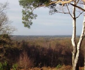
To walk the Finchampstead Ridges is to embark on a ramble through history and nature alike. The terrain undulates gently, offering a variety of paths from broad tracks to winding woodland trails. One of the most popular routes starts at the National Trust car park, following the Ridges northward and affording sweeping views out over the Berkshire countryside. On clear days, the rolling hills and patchwork fields stretch away to the horizon.
The Ridges are a haven for wildlife lovers and walkers alike. The evergreens and ancient birches provide a home to a chorus of songbirds—nuthatches, woodpeckers, and tits fill the air with their calls, while red kites and buzzards wheel overhead. The heather moor, ablaze with purple in late summer, gives way to shaded glades where deer may be glimpsed at dawn or dusk.
Several waymarked walks guide visitors through the area, ranging from brief, contemplative strolls to longer hikes that take in the neighbouring Simon’s Wood and Heath Pool. You may even find yourself following the path of Roman soldiers as the “Devils’s Highway” (an ancient Roman road connecting London to Silchester) passes directly through the Ridges on its way to Eversley). Paths are generally well maintained, though sandy slopes can be challenging after heavy rain. Benches and viewing points are thoughtfully placed, inviting rest and reflection.
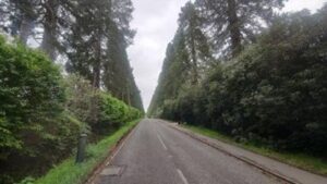
Access to Simons’ Wood Car park is down the Wellingtonia Avenue, a grand and leafy thoroughfare, which traces its origins to the mid-nineteenth century, when it was planted with majestic Wellingtonia (giant sequoia) trees in honour of the Duke of Wellington. Intended as both a living tribute and a striking landscape feature, the avenue formed an impressive approach to the Wellington College estate, bridging cultivated parkland and the wild beauty of the neighbouring Finchampstead Ridges. Over time, the avenue and the Ridges became closely intertwined—not just geographically, but in the shared stewardship of their natural heritage. Today, the towering redwoods of Wellingtonia Avenue stand sentinel at the Ridges’ edge, their presence a reminder of Victorian vision and the enduring partnership between cultivated grandeur and untamed heathland.
Points of Interest in Finchampstead
The Devils Highway
The Devils highway was an old Roman Road connecting London and the Roman settlement of Silchester, crossing the Long River somewhere near the current day Ford at the boundary of Eversley and Finchampstead parishes. It ran right through Finchampstead, which probably owes a lot of the original settlement due to the proximity to this main travelling route.
St James’ Church
St James’ Church is a picturesque parish church perched atop a hill in Finchampstead, offering commanding views of the Berkshire landscape. The church has Norman origins, with its earliest stonework dating back to the 12th century, although it is believed to be built over both Roman and Pagan places of worship. Over the centuries, it has been extended and restored, most recently in 1914, retaining its charming flint and stone exterior, and featuring a distinctive wooden bell turret. Inside, visitors will find a tranquil atmosphere, stained glass windows, and memorials reflecting the village’s long history. The churchyard is also notable for its ancient yew trees and peaceful setting, making it a focal point for the local community and a serene spot for reflection.
The Queen’s Oak (Public House)
Just opposite St James Church, the Queen’s Oak is a historic tree located near the village, steeped in legend and local lore. It is said to mark the spot where Queen Elizabeth I rested and dined during a journey in 1591. Although the original ancient oak has since fallen, a successor now stands in its place, commemorating the royal connection. The tree’s legacy is celebrated in the name of the nearby Queen’s Oak pub, and it remains a point of interest for those exploring the area’s rich heritage. It is believed that this is the only pub in Britain called the Queens’ Oak, so visitors to this lovely establishment are really enjoying a unique experience.
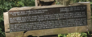
King Henry VII Signpost & Plaque
At one time Finchampstead’s proximity to Windsor and dense woodlands made it the ideal Royal Hunting Ground. Following the footpath from St James’ Church to the Greyhound Pub, the old Longwater Lane, (not to be confused with Longwater Road that is now the main B3016 between Eversley and Finchampstead) at the Finchampstead end was once a main thoroughfare itself. Along this lane, just before the road reverts to footpath you will find the King Henry VII signpost and plaque commemorate a royal visit to Finchampstead. According to local tradition, King Henry VII paused in the village in 1501 while travelling through Berkshire and received word that his eldest son’s (Prince Arthur)bride to be had arrived from Spain in nearby Dogmersfield. The signpost marks the spot associated with his visit, and the accompanying plaque provides historical context, linking the area to the wider tapestry of English royal history. Interestingly in the late 1970’s a housing development replaced much of the original village green where this event was said to happen and the plaque was erected on 21st October 1978 on pieces of a Yew Tree that was cut down to make way for the houses.
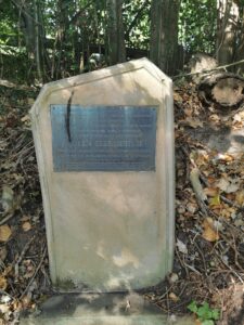
Dozzell’s Well
Dozzell’s Well is an ancient water source nestled within the Finchampstead countryside. The well is thought to date back centuries and was historically an important source of fresh water for local residents and travellers, with the “Red River” flowing from it. The name “Dozzell” is believed to be an adaption of the name of St Oswald, King of Northumbria, who allegedly blessed the well in AD 635 when visiting the King of the West Saxons before marrying his daughter. The Red River is so called because of the strong red colour, due to the geology, but according to the Anglo Saxon Chronicle flowed with blood in times of national crisis and never runs dry. The well was “accidentally” destroyed when the B3348 Fleet Hill Road from the Greyhound to the Tally Ho was widened and today a stone tablet marks the site of the well, which was erected to commemorate the Silver Jubilee of Queen Elizabeth II in 1977. If you are hoping to see it, be warned it’s tucked well into the hedgerow and can easily be missed, but is opposite the aptly named Constant Spring’s Cottage.
Finchampstead Memorial Ground
The memorial ground at Finchampstead is also along the B3348 road through today’s main village, the War Memorial (that the park is named after) commemorates residents who were killed in World Wars 1 and 2 and also, more recently, from Afghanistan. The ground hosts a vast playing field that supports the Finchampstead Cricket Club (Eversley Cricket Club’s local rivals in the Thames Valley league), Hockey, Netball and Football clubs. Tucked away in a corner near the War Memorial there is also a lovely children’s play park.
I hope this short article has given you some more insight into our local neighbours and incited you to pay a visit. Like Eversley, there a number of footpaths criss-crossing the village old and new, a map of which can be freely downloaded from the Parish Council website.
https://www.finchampstead-pc.gov.uk/wp-content/uploads/2020/08/200824-Finchampstead-rights-of-way-map.pdf